Nagaland, with a total land area of 16,579 sq km, is one of the hill States located in the extreme North-Eastern part of India. It is bounded by Myanmar on the East, Arunachal Pradesh on the North, Assam on the West, and Manipur on the South. It is situated between the 26.6 degree to 27.4 degree North Latitude and 98 degree to 96 degree East longitude. The State is mostly mountainous, except those areas bordering Assam valley. Mount Saramati is the highest peak in Nagaland with a height of 3,840 metres, and its range forms a natural barrier between Nagaland and Myanmar. Due to its strategic location, the State has a huge potential to develop into an international business and trade hub in the East Asian region.
Land, Soil and Climate
Soil:
- The soils of state are characterized as sandy loam and sandy clay loam with the pH ranging from 4.5-6.0.
- The organic carbon content is low-medium.
- Available potassium is also low-medium whereas magnesium is high.
- Likewise, calcium is low, nitrate nitrogen is medium-high, sulphur is low-medium and ammonium nitrogen is low.
Agro Climate Zone:
- Sub Alpine temperate zone (1500-3500m MSL)
- Sub tropical Hill Zone (1000-1500m MSL)
- Sub tropical Plain zone (400-1000m MSL)
- Mild tropical Hill zone (200-800m MSL)
Receives south west monsoon rain during summer and northeast monsoon during winter
The average rainfall is between 175cm and 250 cm. Most of the heavy rainfall is during the 4 months from June to September. The rains during April to May are low. Strong winds blow from the North West in February and March.
Annual maximum temperature is 26 0 C and minimum temperature is 210C.
Agriculture and Crops Grown
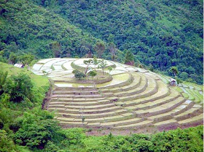
Nagaland is basically a land of agriculture. About 70 percent of the population depends on agriculture. The contribution of agricultural sector in the state is very significant. Rice is the staple food. It occupies about 70 percent of the total area under cultivation and constitutes about 75 percent of the total food production in the state. The major land use pattern is slash and burn cultivation locally known as Jhum. Area under Jhum cultivation is about 1,01,400 hectare and under terraced cultivation.
Crop Rotations:
Paddy- Mustard
Paddy- maize
Paddy- linseed
Maize – Black gram
Soybean –fallow
Paddy-cabbage
Maize- winter vegetables
Cucurbits – winter vegetables
Paddy –fallow
Maize –fallow
Ginger –fallow
Crop Sequences:
Paddy followed by Mustard
Paddy followed by maize
Paddy followed by linseed
Maize followed by Black gram
Soybean followed by fallow
Paddy followed by cabbage
Maize followed by winter vegetables
Cucurbits followed by winter vegetables
Paddy mono crop
Maize mono crop
Ginger mono crops
Inter Cropping: Jhum paddy maize, colocasia, soybean, cucurbits
Mixed Cropping Jhum paddy maize, colocasia, soybean, cucurbits
Cash Crops : Cotton Sugarcane, Jute, Tea, Coriander
Agricultural Trade and Economy
Nagaland Economy is mainly based on agriculture as more than 60% of the population is engaged in this sector. The Economy of Nagaland is also dependent on forestry, cottage industry, and tourism. The gross domestic product of the state Nagaland amounted to 7252 crores in 2006 – 2007, in 2007 – 2008 this figure amounted to 8075 crores, and in 2008 – 2009 this figure stood at 9288 crores. Agriculture contribution to the state GDP is 1676.95 crores in 2006-2007, in 2007 -2008 the figure amounted to 1680.60 crores and in 2008 – 2009 it is 1929.34 crores.
The Economy in the state of Nagaland is dependent mainly on agriculture. The economy’s remarkable feature is that there are no landless peasants in the state. The various kinds of crops cultivated in Nagaland are corn, pulses, oilseeds, fibers, sugarcane, potatoes, tobacco, millets, and rice. In spite of agriculture being the main occupation of the people, the state still has to import food items from other states. This has happened due to the fact that people followed unsustainable agricultural practices such as the Jhumming method which has led to the loss of fertility due to soil erosion. This has hampered the growth of the Economy in Nagaland. The Economy of the state of Nagaland also depends on the forests as the state has a huge forest cover. The state has 33% forest area and they are divided into 3 group such as private forests, reserved forests, and protected forests. The various products from the forests are sold all over the country and this brings in revenue for the Economy of Nagaland. Nagaland Economy also gets its revenue from the state’s cottage industries. The cottage industry in Nagaland manufactures pottery, weaving materials, and woodwork. All the products that are manufactured by the cottage industry are sold all over India and even exported to foreign countries. This has given a major boost to Nagaland Economy.

